

Safe Walking Routes
For the safety and well-being of everyone, please be mindful of these safety tips. The safe route map (below) shows the suggested safe walking routes for Butler Elementary students who walk to school. Arrows depicting walking routes are shown. Please note the following:
1. Students should use existing sidewalks whenever possible.
2. On streets without sidewalks, students should walk on the left side of the street facing oncoming traffic.
3. Our safe routes include two adult crossing guards located at the corner of Ft. Union Blvd. and 2700 East as well as another crossing guard at the corner of 7115 South and 2700 East. Generally, they are on duty one-half hour before and after school begins and again for one-half hour before and after school ends. This includes early-out days.
4. Make your way to a green route on the map below and select the best walking route to school from your home. You may become familiar with the route by walking the route with your child. Your child should follow this route daily. Please instruct your child to observe crosswalks and signs.
5. Children who ride bikes must ride on the right-hand side of the road and never in the middle! When possible, they should cross at intersections where there are adult crossing guards stationed, and they should always walk their bikes across the street. Please train them to be cautious on all streets and intersections where there is no adult supervision. All students are strongly encouraged to wear bike helmets when riding bikes.
6. All students should remember to go straight home from school. Do not talk to, take candy or gifts, or get into the cars of strangers. Any strange behavior should be reported to school staff and/or parents.
7. If you learn of any safety problems or route deficiencies, please report them to the school immediately at 801-826-7975. Thank you for your help with this important issue.
WINTER CONSIDERATIONS
Students who normally use Ft Union Blvd, in the north end of our walking boundaries should take an alternate route through the neighborhood and avoid Ft Union Blvd following significant snowstorms as the sidewalks are often not cleared by residents.
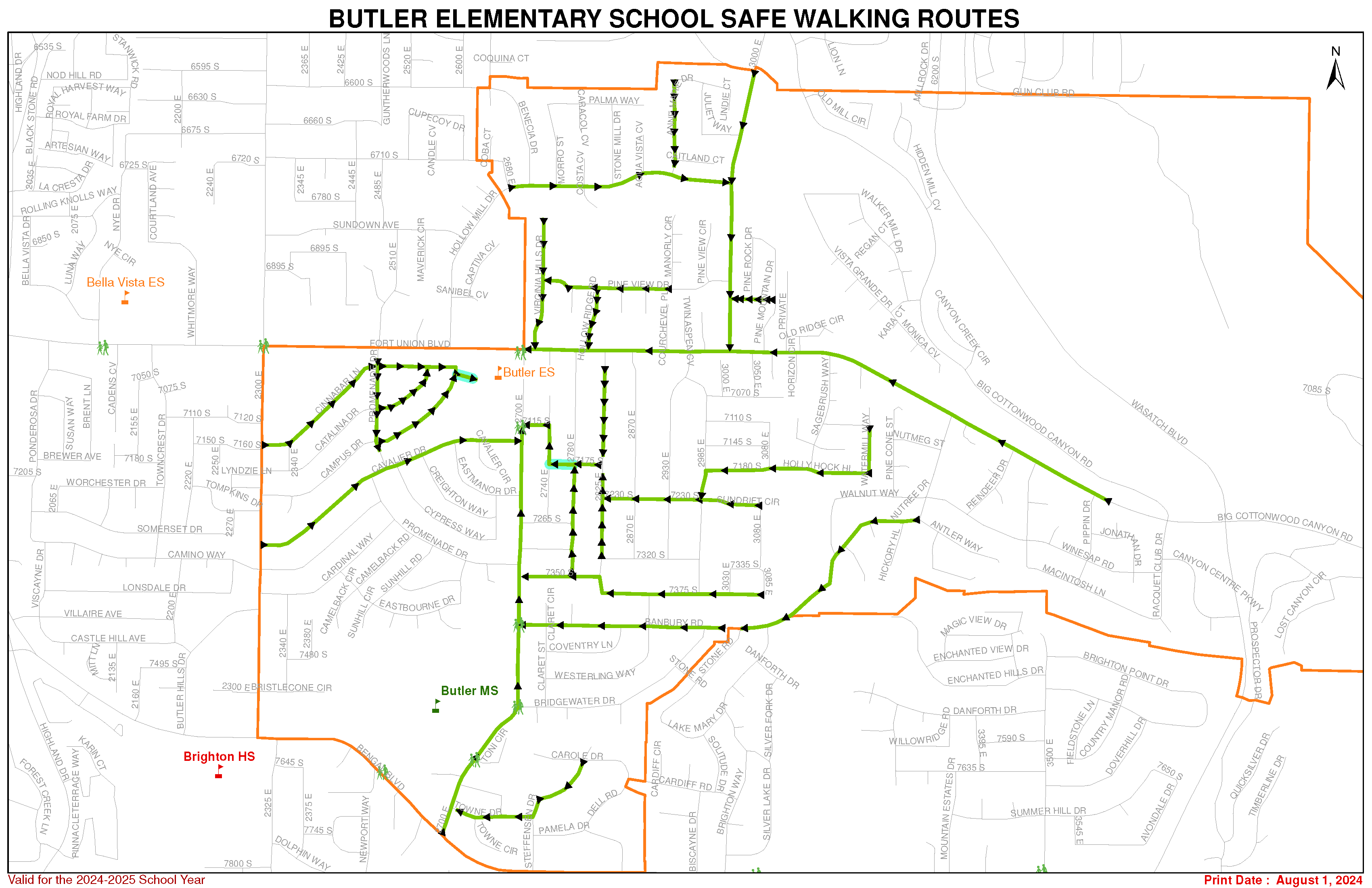
BUTLER HILL AREA:
- Student on 2825 East and 2870 East have two safe walking routes:
- Students walk north to Fort Union Blvd. Staying on the south side of 7000 south using the sidewalk and head west toward Butler to cross at the crosswalk with the guard, or students living on 2870 East may use the catwalk to cross to 2825 East and then follow the directions above.
- (Students on 2870 East us the catwalk to cross to 2825 East.) Students walk to 7175 South, turn west and continue to 2780 East where the catwalk goes through to 2740 East, turn north and walk to 7115 South then go west to 2700 East where a crossing guard will assist them across the street to the school.
- Students on 2780 East have two safe walking routes:
- Students walk south on 2780 East to a catwalk that goes west to 2740 East, turn north and walk to 7115 South, turn west and go to 2700 East, and cross at the crosswalk with the crossing guard to the school.
- Students walk north on 2780 East to Fort Union Blvd., turn west, staying on the south side of 7000 south, continue on the sidewalk to the 2700 East crosswalk and cross the street with the crossing guard.
- Students on 2750 East walk north on 2750 East to Fort Union Blvd. (7000 south). Then they walk west on the south side of 7000 South to the crosswalk and cross 2700 East with the crossing guard.
- Students on 2740 East walk either north or south on 2740 East until they reach 7115 South.They turn west and walk to 2700 East; then they walk south on 2700 East to the crosswalk and cross the street with the crossing guard.
- Students on 2700 East walk either north or south on 2700 East (staying on the side of the road that their houses are on) until they reach one of the crosswalks on 2700 East and cross the street with the crossing guard.
- Students who live east of 2700 East on Fort Union Blvd. (7000 South) walk west on the sidewalk on the same side of the street as their homes until they reach the intersection with the signal, crosswalk, and crossing guard.
- Students who live west of 2700 East on Fort Union Blvd. (7000 South) walk east on the sidewalk on the same side of the street as their homes until they reach the intersection with the signal, crosswalk, and crossing guard.
- Students on 7115 South, 7175 South, 7230 South, 7265 South, 7305 South, 7320 South, 7350 South and 7375 walk west until they come to a north-south road and follow the directions for safely waling to school from that north-south road.
- Students on 3030 East and 3085 East walk south to 7375 South and follow the directions above.
- Students on 7335 South walk to either 3030 East or 3085 East and follow the directions above.
MILL HOLLOW RIDGE AREA:
- Students who live on 2715 East, the west portion of Pineview Drive, Knudsen Ridge Circle, Hollow Ridge Road, Knudsen Mill Road, and Hollow Oak Circle have two safe walking routes: 1. Students may walk through their subdivision; leave the subdivision at Mill Hollow Ridge Road heading south until they reach 7000 South (Fort Union Blvd.), turn west and walk down the sidewalk to the intersection. At the intersection at 2700 East there is a signal, crosswalk and crossing guard.
- Students may walk west on Pineview Drive until it connects with Virginia Hills Drive, turn south and walk south until they reach 7000 South (Fort Union Blvd.).They walk west on Fort Union Blvd. (7000 south) until they reach the intersection at 2700 East where there is a signal, crosswalk, and crossing guard.
- Students in the Aspen Park Condos may exit the condos on Fort Union Blvd. (7000 South), walk west until they reach the intersection at 2700 East where there is a signal, crosswalk, and crossing guard.
MILL HOLLOW AND OVERLOOK AREA:
- Students who live on Moro Street, Costa Cv., Rossbern Cv., Caracol Cv., Palma Way, Anne Marie Drive, Caitland Ct., Juliet Way, and Lind Ct. have two safe walking routes.
- Students may exit their subdivision by walking on sidewalks to Hollow Mill Drive. They walk west then south to the north side of Fort Union Blvd. (7000 South), then turn east and continue on the sidewalk to the intersection at 2700 East where there is a signal, crosswalk, and crossing guard.
- Students may exit their subdivision by walking on sidewalks to Hollow Mill Drive. They walk east to 3000 East, then they walk south to Fort Union Blvd. (7000 South), they then turn west and continue on the sidewalk to the intersection at 2700 East where there is a signal, crosswalk, and crossing guard.
- Students who live on Mill Hollow Drive have two safe walking routes.
- Students walk west then south to the north side of Fort Union Blvd. (7000 South), they then turn east and continue on the sidewalk to the intersection at 2700 East where there is a signal, crosswalk, and crossing guard.
- Students walk east to 3000 East, then they walk south to Union Blvd. (7000 South), they then turn west and continue on the sidewalk to the intersection at 2700 East where there is a signal, crosswalk, and crossing guard. • Students on Benicia Dr. walk south/southwest on Benicia Dr. until they reach Hollow Mill Drive. They walk west then south to the north side of Fort Union Blvd. (7000 South), then turn east and continue on the sidewalk to the intersection at 2700 East where there is a signal, crosswalk, and crossing guard.
VIRGINIA HILLS DRIVE AREA:
- Students walk south until they reach 7000 South (Fort Union Blvd.), turn west a short distance until the intersection at 2700 East where there is a crosswalk, signal and crossing guard.
WALNUT WAY AREA:
- Students on Walnut Way, Nutree Drive, Hickory Hill, Pecan Circle and Chestnut Circle may walk through Bywater Park catwalk to 7375 South down to 2980 East, turn west on 7230 South, continue west until 2825 East.Then they walk north to 7175 South and take the catwalk to 2740 East, turn north to 7115 South and walk to the crosswalk on 2700 East to the school.
- Students on Nutmeg St., Pine Cone St. and Pinion Place may walk east on Nutmeg St. to Nutree Dr., turn north and continue walking to Fort Union Blvd. Turn and continue walking on the sidewalk to the intersection at 2700 East where there is a signal, crosswalk, and crossing guard.
- Students on Marinda way, 3320 East, and Antler Way have two safe walking routes:
- Students walk to the intersection of Antler Way and Nutree Drive. They walk north east on Nutree Drive on the sidewalk to Fort Union Blvd. (approx. 7100 South), they turn west and continue to the intersection at 2700 East where there is a signal, crosswalk, and crossing guard.
- Students walk to the intersection of Antler Way and Nutree Drive and continue south/southwest on Nutree Drive to the Bywater Park catwalk to 7375 South, then down to 2980 East, turn west on 7230 South, continue west until 2825 East. Then they walk north to 7175 South and take the catwalk to 2740 East, turn north to 7115 South and walk to the crosswalk on 2700 East to the school.
GRIFFITH PLACE
- Students should walk west on 7000 South to the intersection at 2700 East where there is a crosswalk, signal and crossing guard.
APPLE VALLEY AREA:
- Students on Fawn Cr., Reindeer Dr., Buck Cr., Winesap Road, west and north parts of Macintosh Ln., Macintosh Cr., Winesap Ct., Jonathan Cr., Winesap Cr., and the north end of Racquet Club Drive have two safe walking routes.
- Students may go out of their subdivision and walk on the sidewalk down Fort Union Blvd. (approx. 7200 South) to the intersection at 2700 East where there is a crosswalk, signal and crossing guard.
- Students may walk up Nutree Drive, through the Bywater Park catwalk down to 7375 South to 2985 East, turn on 7230 South and continue west to 2825 East, then north until 7175 South and take catwalk to 2740 East, turn north to 7155 South and walk west to 2700 East and cross with the crossing guard.
RIVIERA HEIGHTS AREA:
- Students on the west end of Cavalier Dr., Campus Dr., Catalina Dr., and Cinnabar Ln. would walk east on their streets to Promenade Dr. They should continue east to the back of the school and go through catwalk to the school.
- Students on the north end of Promenade Drive have two safe routes: 1. Students may walk north on Promenade Drive to Fort Union Blvd. (7000 south), turn east and walk on the south sidewalk to 2700 East. 2. Students may walk south on Promenade Drive and enter the school grounds through the catwalk at the back of the school.
- Students on the south end of the Promenade Drive have two safe routes:
- Students may walk northwest on Promenade Drive to Cavalier Drive, continue east to 2700 East, turn north and continue on the west sidewalk to the school.
- Students may walk east until 2700 East, then turn north and continue on the west sidewalk to the school.
- Students on Cypress Way, Creighton Way, and the East Manor Drive have two safe walking routes:
- Students walk northwest on their streets to Cavalier Drive, turn southwest on Cavalier Drive to Promenade Drive and enter the school grounds through the catwalk at the back of the school.
- Students walk southeast on their streets to north/south section of Cypress Way, turn east on East Manor Drive to 2700 East. They continue walking on the west sidewalk on 2700 East to the school. • Students on the east part of Cavalier Dr. continue walking east to 2700 East, turn north and continue on the west sidewalk to the school.
- Students on Cavalier Cr. Walk to Cavalier Dr., then walk east to 2700 East, turn north and continue on the west sidewalk to the school.
- Students on Camino Way, Cardinal Way, Camelback Road, Camelback Circle, Sunhill Road, Sunhill Circle, Eastbourne Drive, Eastbourne Circle, Carling Circle, and Bourne Circle have two safe routes to school.
- Students walk on their streets to Promenade Drive, turn northwest on Promenade Drive to Cavalier, turn east to the north part of Promenade Drive and enter the back of the school through the catwalk.
- Students walk on their streets to Promenade Drive, turn east on Promenade and continue to 2700 East, then turn north and continue on the west sidewalk to the school.
- Students on Bristlecone Drive, 2340 East, 7480 South, and 2380 East walk on their streets until they reach 2340 East. They continue on 2340 East until they reach Cardinal Way. They follow the directions above for Cardinal Way.
- Students on the east side of 2300 East have two safe routes to school:
- They may walk north on the east sidewalk of 2300 East to Fort Union Blvd. (7000 South), then they walk on the south side of Fort Union Blvd. to 2700 East to the school.
- They may walk up Bristlecone Dr., Cardinal Way, Camino Way, Cavalier Dr., Campus Dr., Catalina Dr., or Cinnabar Ln. and follow the directions for those streets.
PINE COVE AREA:
- Students on 2930 East, 2980 East, 2955 East, and 2985 East have two safe walking routes: 1. They may walk north on their streets to Fort Union Blvd. (7000 South), then turn west and continue walking on the south sidewalk until they reach the intersection at 2700 East where there is a signal, crosswalk, and a crossing guard.
- They may walk south on their streets to either 7230 South or 7320 South, turn west and continue to 2825 East. Then they walk north to 7175 South, turn west and continue to 2780 East where a catwalk goes through to 2740 East, turn north and walk to 7115 South then go west to 2700 East where a crossing guard will assist them across the street to the school.
- Students on Hollyhock Hill, 7134 South, 7145 South, 7110 South and 7070 South walk west on their streets to 2985 East and then follow the directions above.
- Students on 3000 East walk to 7070 South and then follow the directions above.
- Students on Horizon Cr. Walk north to Fort Union Blvd. (7000 South) turn west and walk on the north sidewalk to the intersection at 2700 East where there is a signal, crosswalk, and crossing guard.
- Students on Turnagain Cv., Candytuft St., Sagebrush Cr., Barnwood Bay, Barnhill Bay and Sagebrush way walk on their streets to Sagebrush way.They continue north on the Sagebrush Way to Fort Union Blvd. (7000 South), turn west and walk on the north sidewalk to the intersection at 2700 East where there is a signal, crosswalk, and crossing guard.
- Students on Watermill Way walk to Candytuft St. or Hollyhock Hill, then turn west to Sagebrush Way.They continue north on Sagebrush Way to Fort Union Blvd. (7000 South), turn west and walk on the north sidewalk to the intersection at 2700 East where there is a signal, crosswalk, and crossing guard.
BRIGHTON HILL ESTATE AREA:
- Students on Towne Drive, Canterbury Lane, and Toni Circle, should walk west on their streets to 2700 East, then walk north on the east sidewalk to 7635 South where they may cross 2700 East with the crossing guard.They continue on the west sidewalk on 2700 East to the school.
- Students on Carole Drive, Dell Road, Pamela Drive, 2730 East, and Steffensen Drive walk on their streets to Stefffensen Drive and Towne Drive. They then follow the directions above.
PINE MOUNTAIN AREA:
- Students who live on 6920 East, Pine Rock Dr., Pine Rock Cr., Pine Mountain Drive have two safe walking routes.
- Students may exit their subdivision on 3000 East, walk on the north sidewalk of Fort Union Blvd. (7000 South), crossing 3000 East at the crosswalk, and continue until they reach the intersection at 2700 East where there is a signal, crosswalk, and crossing guard.
- Students may exit their subdivision on 3055 East, walk on the north sidewalk of Fort Union Blvd. (7000 South), crossing 3000 East at the crosswalk, and continue until they reach the intersection at 2700 East where there is a signal, crosswalk, and crossing guard.
- Students who live on 3000 East may walk south on 3000 East until they reach 7000 South (Fort Union Blvd.). If they live on the east side of 3000 East, they cross 3000 East at the crosswalk. They walk west until they reach the intersection at 2700 East where there is a signal, crosswalk, and crossing guard.
- Students who live on 2930 East, Manorcrest Cr., Manorview Ct., Manorly Circle, 6890 South, 2965 East, and Pine View Cr. May exit their subdivision on Pine View Drive or 6890 South and walk east to 3000 East then follow the directions above.
BANBURY AREA:
- Students on Sundrift Circle and 7375 South areas have two safe walking routes:
- Students walk west on Sundrift Circle and continue west to 2825 East. They turn north to 7175 south and through the catwalk to 2740 East. Then they turn north to 7115 South and walk west to 2700 East and cross with the crossing guard.
- Students walk west on 7375 South to 2985 East then west to 2825 East.They turn north to 7175 South and walk through the catwalk to 2740 East and continue north to 7115 South, then walk west to 2700 East and cross at the crosswalk with the crossing guard.
BUS ZONE AREAS:
A Canyons School District bus services both Old Mill and Prospector areas of Butler boundaries. This is a disclaimer statement regarding why these areas are not indicated on the map as a safe walking route. The danger of having students walk along Big Cottonwood Canyon Road and crossing Wasatch Blvd. Is extremely high, therefore no safe walking route description exists.
WINTER CONSIDERATIONS
Students who normally use Ft Union Blvd, in the north end of our walking boundaries should should take an alternate route through the neighborhood and avoid Ft Union Blvd following significant snowstorms as the sidewalks are often not cleared by residents.
- Students north of Ft Union Blvd should make their way to Pine View Dr and walk west to Virginia Hills Drive. Walk south on Virgina Hills Dr and use the crosswalk at 2700 East to access the school.
- Students who live south of Ft Union Blvd and Easy of 2700 East have two options:
- Students who live the far eastern end of the walking boundary should walk east along Winesap, Walnut Way and Banbury Road to 2700 East then walk north until reaching the school crossing guard and the south side of the school parking lot.
- Students who live between Sagebrush and 2870 East should make their way south to the East-West corridor of Hollyhock Hill/7180 South/7230 South. Walk west along this route until reaching 2825 East. Proceed north to 7175 South. Use the catwalk to access 2740 East. Walk north to 7115 South. Move head west and utilize the school crossing guard and the south side of the school parking lot.